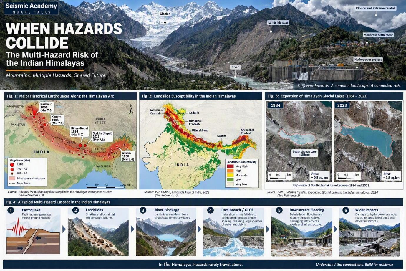
Why Earthquakes, Landslides, Floods, and Glacial Lake Outburst Floods Are No Longer Independent Disasters
Imagine standing in a Himalayan valley on a clear morning. A glacier is retreating in the distance. Scars from earlier landslides mark the mountainsides, while a river rushes through a narrow gorge lined with settlements, roads and hydropower infrastructure. Deep beneath your feet, the collision of the Indian and Eurasian tectonic plates continues to shape one of the world's most seismically active mountain regions.
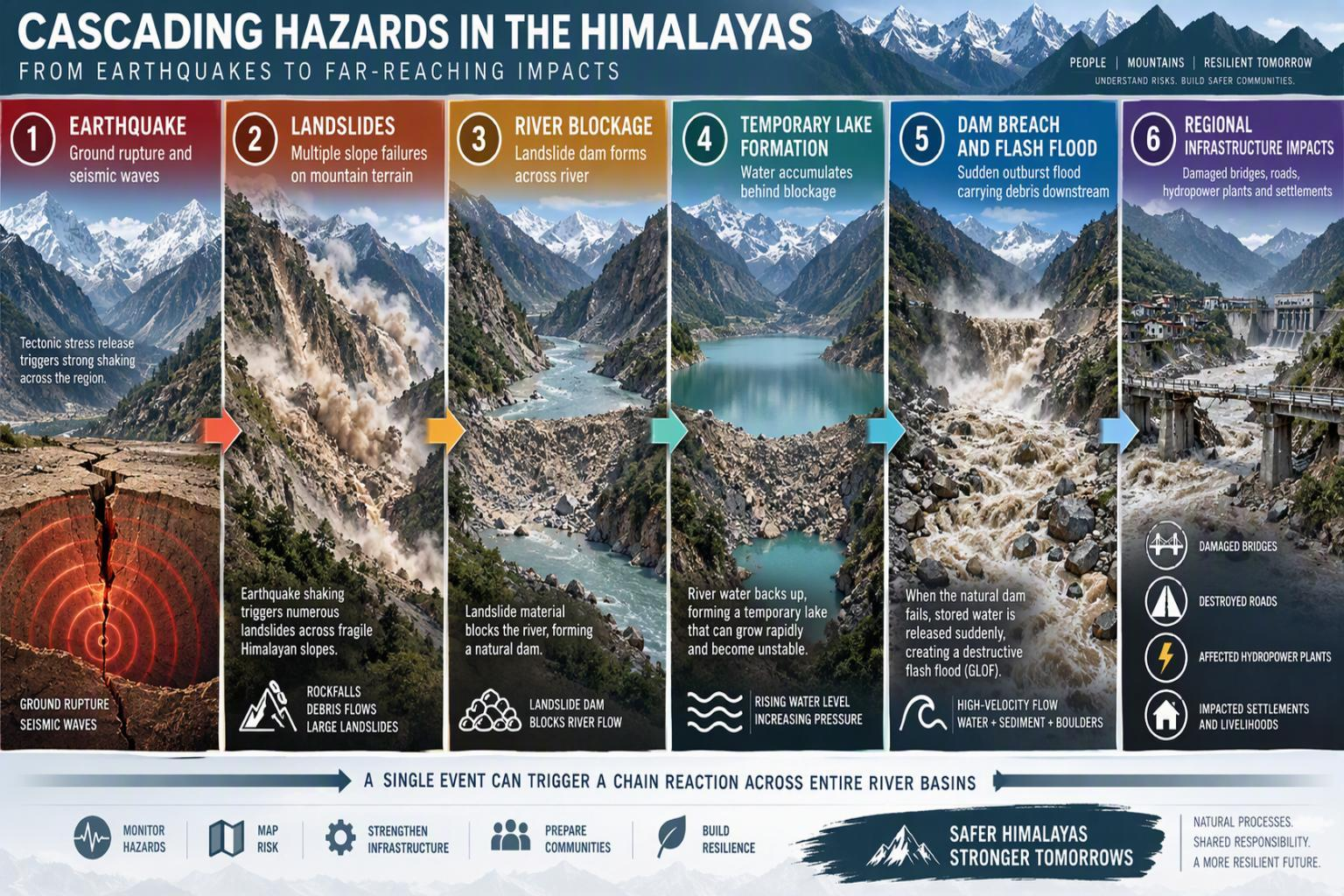
An earthquake can trigger landslides. A landslide can block a river, forming a temporary dam that may eventually breach and unleash destructive floods. An avalanche entering a glacial lake can trigger a glacial lake outburst flood (GLOF). Meanwhile, intense rainfall can saturate slopes, destabilise terrain and damage infrastructure.
In the Indian Himalayas, disasters rarely unfold in isolation. Earthquakes, landslides, flash floods, avalanches and glacial lake outburst floods can interact, amplifying their impacts and triggering cascading failures.
Understanding these connections is essential to designing infrastructure that can withstand not just an individual hazard, but the chain of secondary hazards that may follow.
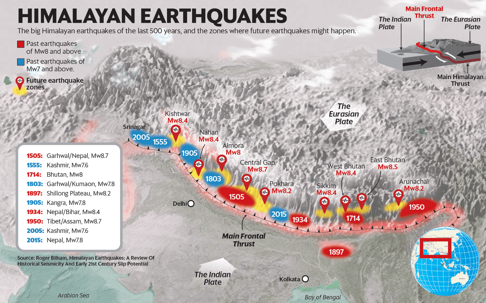
Unlike older mountain ranges, the Himalayas are still being actively formed by the collision of the Indian and Eurasian tectonic plates. Studies indicate that convergence between the Indian and Eurasian plates continues at approximately 30-50 mm per year, with a significant portion of that deformation being accommodated within the Himalayan region. This ongoing tectonic activity makes the Himalayas one of the most seismically active mountain belts on Earth. The region's earthquake history offers a stark reminder of this risk. Several major Himalayan earthquakes have caused widespread destruction across India and neighbouring countries.
Major Historical Earthquakes Along the Himalayan Arc:
These events demonstrate that the Himalayan arc can generate great earthquakes exceeding magnitude 8.
Figure 1. Major Historical Earthquakes Along the Himalayan Arc
Hazard #1: Earthquakes - The Original Trigger
When engineers assess risk associated with natural hazards in the Himalayas, earthquakes often receive the most attention, and for good reason. But their destructive effects do not end when the ground stops shaking.
They also trigger numerous secondary hazards. The 2015 India-Nepal earthquake generated widespread slope failures across mountain valleys.
Large earthquakes may initiate one or multiple secondary hazards like:
Research on Himalayan seismicity highlights that earthquake impacts extend well beyond shaking damage and can persist for years through slope destabilisation and altered drainage systems.
Hazard #2: Landslides - The Most Frequent Himalayan Disaster
If earthquakes are the most feared Himalayan hazard, landslides are the most frequent.
The National Remote Sensing Centre (Key constituent Centre of ISRO) compiled a geospatial inventory of approximately 80,000 landslides mapped across India's vulnerable mountainous regions between 1998 and 2022.
The Himalayan region experiences landslides due to:
Recent disasters in Himachal Pradesh, Uttarakhand, and Sikkim demonstrate how rainfall-induced slope failures can damage roads, bridges, settlements, and utility infrastructure within minutes.
Figure 2. Landslide inventory of India (1998-2022) Hazard #3: Glacial Lake Outburst Floods (GLOFs) A New Threat Emerging from a Changing Cryosphere
The Himalayas are often called the “Third Pole” because they contain one of the largest reserves of ice outside the Arctic and Antarctic regions.
As glaciers retreat, new glacial lakes are forming and existing lakes are expanding.
These changes make glacial lake outburst floods (GLOFs) an important hazard to monitor across the Indian Himalayan region.
Satellite analyses by ISRO have identified:
Figure 3. Expanding Glacial Lakes in the Indian Himalayas (1984-2023)
The National Disaster Management Authority (NDMA) of India has identified Jammu & Kashmir, Ladakh, Himachal Pradesh, Uttarakhand, Sikkim, and Arunachal Pradesh among the regions vulnerable to GLOF hazards.
How Does a GLOF Occur?
A glacial lake can suddenly release massive water volumes when:
The resulting flood can travel downstream at extreme velocities while carrying rocks, sediment, and debris.
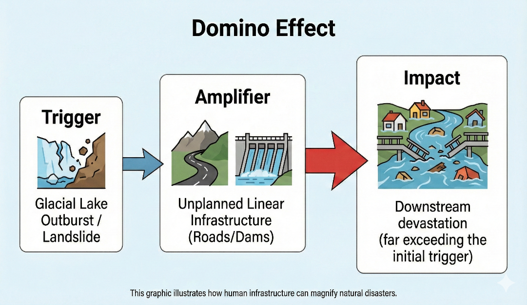
The engineering concern extends along the entire downstream flow path, where exposed infrastructure and communities may have little time to respond.
Figure 4. Illustration of how human infrastructure can magnify natural disasters
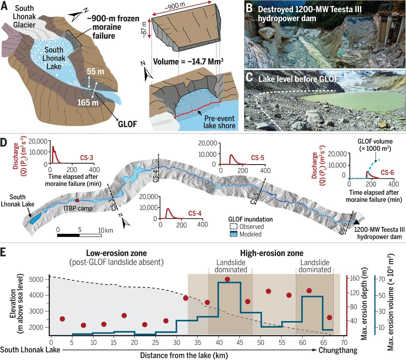
Case Study: South Lhonak Lake, Sikkim
The October 2023 South Lhonak GLOF demonstrated the growing vulnerability of Himalayan infrastructure to cascading hazards.
The event caused severe flooding along the Teesta basin and damaged downstream assets, including hydropower infrastructure. NDMA and national agencies have since expanded monitoring and risk-reduction initiatives.
Figure 5. The Sikkim flood of October 2023: Drivers, causes, and impacts of a multi-hazard cascade Hazard #4: Cloudbursts and Flash Floods
Some Himalayan disasters do not start in glaciers.
They start in the atmosphere with intense rainfall, which can rapidly increase river discharge, saturate slopes and trigger landslides
Examples include:
These events highlight how short-duration extreme rainfall can transform mountain streams into devastating torrents.
The challenge, therefore, is not rainfall alone. It is understanding how rainfall, terrain, river systems, and infrastructure interact.
The traditional way of assessing hazards asks: Which hazard is most dangerous?
The better question is: Which hazard starts the chain reaction?
Consider the following realistic scenario:
Fig. 6: Cascading Hazards in the Himalayas amplifying impacts across entire mountain valleys
This is why modern disaster risk studies increasingly focus on multi-hazard and cascading-risk assessments, rather than treating individual hazards independently.
Historically, infrastructure was often designed for a single dominant hazard.
Today's Himalayan projects may face overlapping exposure to:
For engineers, the challenge is to translate these interacting risks into practical design and planning decisions.
A truly resilient project must answer multiple questions:
Multi-Hazard Risk Assessment Must Become Standard Practice
Every major infrastructure project in the Himalayan region should include a multi-hazard risk assessment that evaluates:
Expand Monitoring Systems
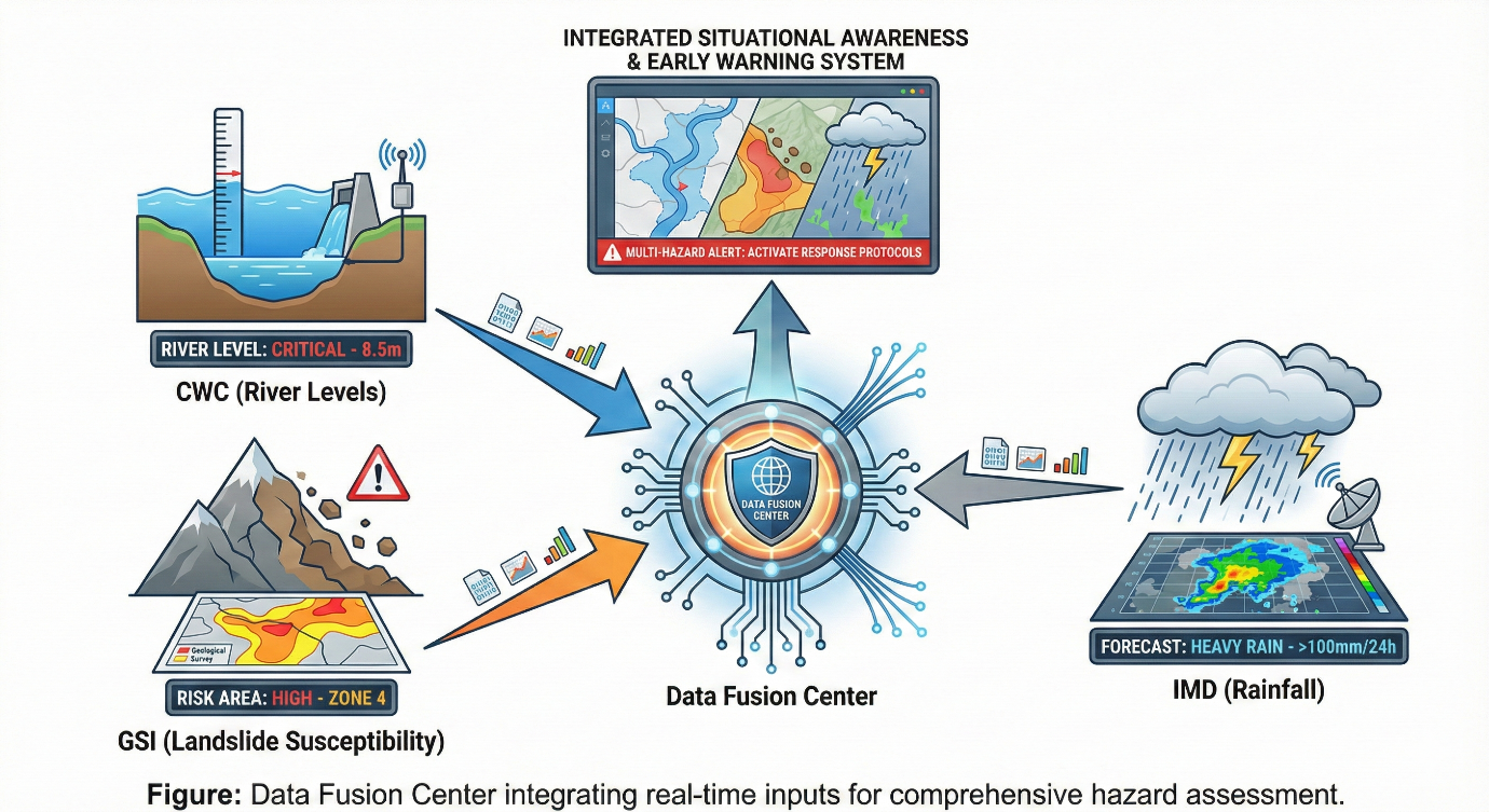
Greater use of the following technologies can help detect changes in high-risk areas and support timely warnings before disasters occur.
Fig 7: Integrated situational awareness and early warning system support timely disaster response.
Build Infrastructure for Cascading Events
Design philosophy must shift from:
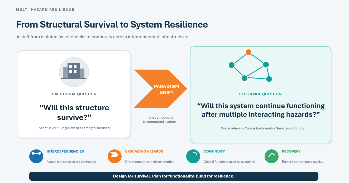
“Will this structure survive?”
to:
“Will this system continue functioning after multiple interacting hazards?”
Fig 8: Structural survival to system resilience ensure that interconnected infrastructure continues functioning through cascading hazards
The Himalayas have always been shaped by powerful natural forces. What is changing is the extent of our exposure to them.
More roads are being built that cut through steep slopes. Dams and hydropower projects alter river systems. Tunnels extend deeper into mountain terrain, while growing tourism and settlements bring more people and infrastructure into hazard-prone areas. At the same time, a changing climate is interacting with an already active tectonic landscape, adding further complexity to the risks.
The next Himalayan disaster may begin as an earthquake, a landslide, a cloudburst, or a glacial lake breach. But it will likely not end there, triggering a chain of failures that disrupt infrastructure, isolate communities and complicate emergency response.
Because in the Himalayas, hazards rarely travel alone.
The future of Himalayan resilience lies not in understanding individual hazards. It lies in understanding how hazards interact.
Study the mountains. Respect their complexity. Design for the cascade, not just the trigger.
When Hazards Collide: Understanding Multi-Hazard Risk in the Indian Himalayas
1. Introduction: The Mountains That Never Stop Moving
2. The World's Youngest Mountains Are Still Growing
Earthquake
Magnitude (Mw)
Kangra, 1905 7.8 Bihar-Nepal, 1934 8.2 Assam, 1950 8.4 Kashmir, 2005 7.6 India-Nepal, 2015 7.8
 Key Message
The next Himalayan disaster may not begin with rain or floods. It may begin with a deep underground fault rupture.
3. Hazards in the Himalayas
Engineering Lesson
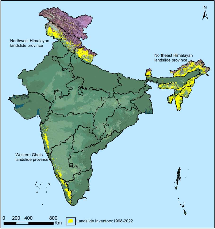
(Source: Landslide Atlas of India)
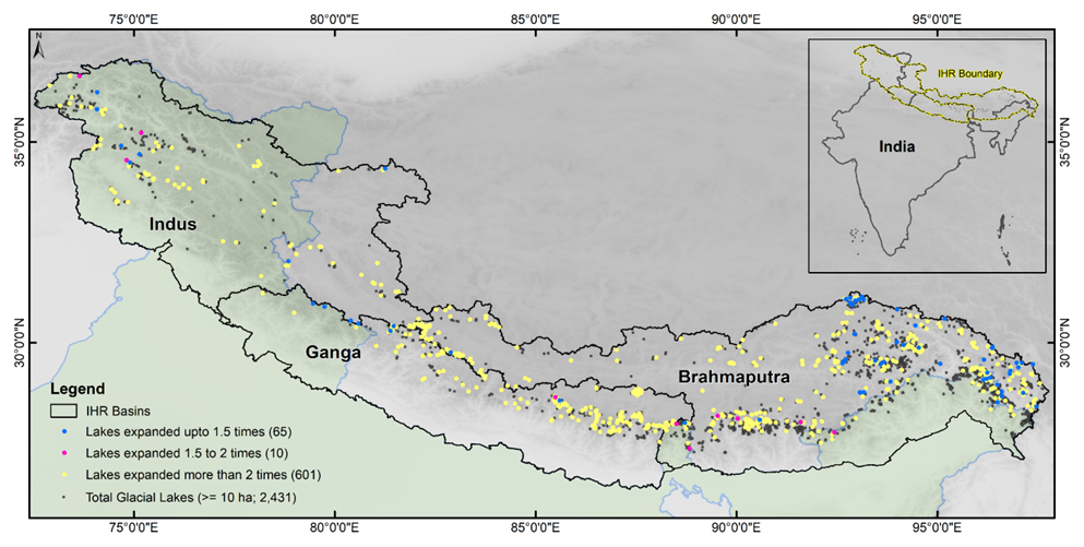
(Source: DOI: 10.1126/science.ads2659)
4. The Real Danger: Cascading Hazards
5. Why Engineers Must Advance Their Thinking
If the answer to any one of these is no, resilience remains incomplete.
6. What Should Be Done?
7. Final Thought
“The Himalayan region is currently at the convergence of climate extremes, geomorphic fragility, and a high anthropogenic footprint. It risks being locked in a vicious cycle if development planning is not reoriented to account for ecological thresholds.”
Acknowledgement:
Dr Prateek Roshan
Engineering Content Manager, Hilti India
Leave a Comment